The continent-spanning nature of the United States means that we have a lot of different geologic conditions. The eastern half of the country is in the (mostly) stable part of the North American plate while the western half (including Alaska) is in the much more dynamic part of the plate. However, that doesn’t mean that the earthquake hazards that our cities face is only a worry for someone living in California.
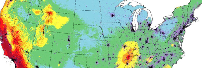
The latest model of potential earthquake shaking hazard for the country was recently released by the US Geological Survey. This model is built on past data of earthquakes, new information about tectonic activity over sometimes the past tens of thousands of years and better understanding of the material on which our cities sit. Earthquakes of all sizes are occurring all the time across the planet and our country.
USGS map showing the chances of damaging shaking due to earthquakes in the US. Credit: USGS.
The map can sometimes be misinterpreted. The color coding isn’t telling us that a specific spot is more or less likely to be the site of an earthquake. Rather, it tells is the chance that a specific spot will feel the shaking caused by an earthquake. That temblor might be nearby or much further away. So, think of the map as a way to understand the likelihood of shaking from the sum of potential earthquakes that could be felt from that location … and in particular, the map focus on damaging shaking.
Let’s take a couple examples. If you live in Oakland, California, there are a lot of faults that crisscross the landscape in all directions from the San Francisco Bay Area. You might feel shaking from any number of earthquakes. Some of those might be large earthquakes whose epicenters are hundreds of miles away or it might be smaller earthquakes locating almost directly underneath you. The combination of all these potential sources of shaking gives you a very high likelihood of damaging shaking in the next century (>95%).
Now, let’s say you are living in Minneapolis, Minnesota. There are very few potentially active faults in this old, stable part of North America. In fact, the closest area that we know of that might produce large, damaging earthquakes is all the way down in the New Madrid fault zone near where Missouri, Arkansas, Kentucky and Tennessee meet. That’s over 600 miles away. You would need a very large (>M7?) earthquake in that region to even cause noticeable let alone damaging shaking in Minneapolis. The chances of damaging shaking in the Twin Cities is very low, likely <5% in the next 100 years.
There are two ways that Earth scientists compare earthquakes. Most people are at least colloquially familiar with the Richter scale. This scale encapsulates the “magnitudes” of earthquakes we hear about on the news. The Richter scale is a scale that compares the energy released in an earthquake.
Map showing the estimates of earthquake shaking ranked by the modified Mercalli scale. This map shows the areas and shaking that have a 2% chance of feeling over the next 50 years. Credit: USGS, Peterson et al. (2023), Earthquake Spectra
However, the magnitude of the earthquake doesn’t necessarily capture the damage produced by an earthquake. There can be high magnitude earthquakes (>M6) that cause less damage than a smaller (M5) earthquake. Much of what controls the difference is the type of rock and sediment on which our cities and structures are built. In order to compare the impact of an earthquake, Earth scientists use the Mercalli scale. This scale ranks the types of damage and shaking felt in an earthquake. If you’ve ever looked at a USGS “Did You Feel It” map, it is employing the Mercalli scale to show how shaking differed across a region due to an earthquake.
This takes us back to the potential earthquake shaking hazard different parts of the US. You might live hundreds of miles from an earthquake that occurred in the lowlands of South Carolina (not a geologically uncommon event), but the sediment and rocks that are underneath the south eastern parts of North America mean the shaking could be more intense that you might have guessed. This might mean that Atlanta has a larger chance of shaking from an earthquake than the tectonic setting of the city implies.
Map showing the locations that have a ~2% chance of maximum 5.0s acceleration due to an earthquake. The New Madrid fault zone stands out as a bullseye in the middle of the continent. Credit: USGS, Petersen et al. (2023), Earthquake Spectra.
This effect is most prominent in the way that a large (M6+) earthquake in the New Madrid area of North America can really make the country “ring like a bell”. The acceleration due to earthquake shaking (a measure of how much shaking you might feel) shows a massive bullseye coming out from the New Madrid area. This means that a M7 earthquake from this area could be noticed much further from the epicenter than the equivalent size temblor in California thanks to the old, cold crust that sites under the eastern US.
None of this is to say you need to panic over the potential earthquake hazards in the US. Some places are much more likely to experience an earthquake, but we all face potential hazards of different kinds. Check out what you can do to stay safe in the event of an earthquake. On top of that, you should always be prepared for a potential disaster that could impact your life for days or longer.
Source : Discovermagazine


